


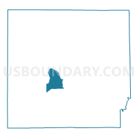
MARION 05A, Lawrence County, Indiana
About
Outline

Summary
| Unique Area Identifier | 578960 |
| Name | MARION 05A |
| County | Lawrence County |
| State | Indiana |
| Area (square miles) | 7.42 |
| Land Area (square miles) | 7.22 |
| Water Area (square miles) | 0.20 |
| % of Land Area | 97.28 |
| % of Water Area | 2.72 |
| Latitude of the Internal Point | 38.80835310 |
| Longtitude of the Internal Point | -86.53598230 |
Maps


Graphs
Select a template below for downloading or customizing gragh for MARION 05A, Lawrence County, Indiana


Neighbors
Neighoring Voting District (by Name) Neighboring Voting District on the Map
- INDIAN CREEK SOUTH, Lawrence County, IN
- MARION 05B, Lawrence County, IN
- MARION 06, Lawrence County, IN
- SHAWSWICK 13, Lawrence County, IN
- SHAWSWICK 15, Lawrence County, IN
- SPICE VALLEY SOUTH, Lawrence County, IN
Top 10 Neighboring County Subdivision (by Population) Neighboring County Subdivision on the Map
- Shawswick township, Lawrence County, IN (20,469)
- Marion township, Lawrence County, IN (9,449)
- Indian Creek township, Lawrence County, IN (2,775)
- Spice Valley township, Lawrence County, IN (2,423)